Both individual vehicles and traffic support applications need a reliable, dynamic and real-time view of the traffic. The Local Dynamic Map (LDM) model is developed to provide the required solution.
The concept of LDM is to structure and share all traffic-related information which could be collected with different frequency intervals from multiple sources. Such an information source could be stationary objects, vehicles, signals, radars, any sensors along the roads, and various traffic management applications. Many route planning, traffic monitoring and alerting applications are using this model already.
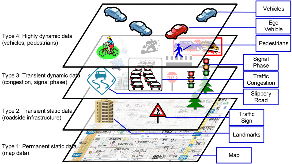
LDM model defines four different layers of information gathering and data processing. Quote from the article of Implementation and Evaluation of Local Dynamic Map in Safety Driving Systems by Hideki Shimada, Akihiro Yamaguchi, Hiroaki Takada, Kenya Sato: ‘…The first or bottom layer consists of static data such as road data, the second layer consists of relatively static data such as signals not included in map data, the third layer consists of relatively dynamic data such as congestion and other traffic conditions, and the fourth or top layer consists of dynamic data such as automotive sensor information…’
LDM also described the database structure and interfaces among the different applications and the LDM database.
LDM concept is more than ten years old, and different projects have been completed already. In Europe, e.g. SAFESPOT INTEGRATED PROJECT was completed by 2010. [23]. The Telecommunication Industry is using the LDM model as well to define the required connectivity among traffic objects. In 2011 ETSI already considered applications based on LDM, where all relevant data was stored from the traffic situations and shared with the vehicle. [19][20]
Example of potential use cases requesting an LDM solution
In 2016, the European Commission adopted a European Strategy on Cooperative Intelligent Transport Systems (C-ITS). Large-scale deployment of the following use-cases was expected by 2019:
Day 1 C-ITS services list
Hazardous location notifications:
- Slow or stationary vehicle(s) & traffic ahead warning;
- Road works warning;
- Weather conditions;
- Emergency brake light;
- Emergency vehicle approaching;
- Other hazards.
- Signage applications:
- In-vehicle signage;
- In-vehicle speed limits;
- Signal violation / intersection safety;
- Traffic signal priority request by designated vehicles;
- Green light optimal speed advisory;
- Probe vehicle data;
- Shockwave damping (falls under European Telecommunication Standards Institute (ETSI) category ‘local hazard warning’).
Further services were expected by the EU to reach a certain maturity level by 2019 even without rolling out in large scale:
Day 1.5 C-ITS services list
- Information on fuelling & charging stations for alternative fuel vehicles;
- Vulnerable road user protection;
- On-street parking management & information;
- Off-street parking information;
- Park & ride information;
- Connected & cooperative navigation into and out of the city (first and last mile,
- parking, route advice, coordinated traffic lights);
- Traffic information & smart routing.
Regardless of the actual status of these developments, an LDM solution is required to roll out these services.
References
[19] European Telecommunications Standards Institute (ETSI): Local Dynamic Map (LDM) Draft ETSI EN 302 895 V1.0.0 (2014-01) ETSI: https://www.etsi.org/deliver/etsi_en/302800_302899/302895/01.00.00_20/en_302895v010000a.pdf
[20] European Telecommunications Standards Institute (ETSI): Local Dynamic Map (LDM) ETSI TR 102 863 V1.1.1 (2011-06) https://www.etsi.org/deliver/etsi_tr/102800_102899/102863/01.01.01_60/tr_102863v010101p.pdf
[22] . Hideki Shimada, Akihiro Yamaguchi, Hiroaki Takada, Kenya Sato: Implementation and Evaluation of Local Dynamic Map in Safety Driving Systems. https://www.scirp.org/pdf/JTTs_2015033117331447.pdf
[23] SAFESPOT INTEGRATED PROJECT http://www.safespot-eu.org/
Like!! Really appreciate you sharing this blog post.Really thank you! Keep writing.